Click here to sign up for our free daily newsletter
(Image Credit: ID 31976814 © Welcomia | Dreamstime.com)
Severe Weather

Wednesday storm could have produced a tornado in Northern Sask: ECCC

Jul 17, 2026 | 6:01 AM

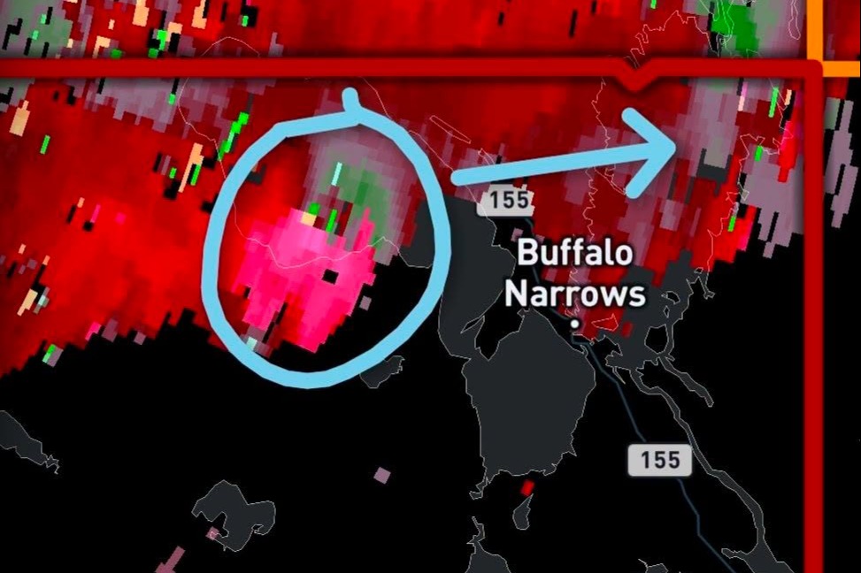
A significant storm in Northern Saskatchewan on Wednesday night could have spawned a tornado near Buffalo Narrows. 

That’s according to Environment and Climate Change Canada (ECCC), where meteorologist Brian Proctor confirmed the organization was monitoring a serious storm in the area through the night. 

“We had a severe thunderstorm tracking across that area and saw a pretty good lightning strike activity associated with it. A little bit of a decent rotation on radar; it’s right at sort of the limit of the radar to a certain degree to see that rotation, but definitely there was a supercell thunderstorm tracking across that area last evening.” 

ECCC issued a red level tornado warning for the areas around Peter Pond Lake just before 10 p.m., saying a possible tornado was on the ground roughly 40 km west of Buffalo Narrows and was tracking southeast at 25 km/h. 

No visual confirmation of a tornado was made to ECCC, nor was any tornado damage reported.

An screenshot taken of a radar showing the signature of the worst of Wednesday's storm, which could have dropped a tornado.
An screenshot taken of a radar showing the signature of the worst of Wednesday’s storm, which could have dropped a tornado. (Image Credit: Saskatchewan Storm Watch/Facebook)

“Whenever we get these kinds of severe thunderstorms that show some rotation, there’s always a possibility that we could get a tornado on the ground. What I would say is we saw some rotation aloft in the atmosphere and that would be indicative of the potential of producing something.” 

Proctor continued that violent storms aren’t abnormal for the region as strong winds have been known to knock down portions of forests, while large amounts of hail have also been recorded there over the years. He said that while tornadoes are a much rarer phenomenon in the north, there are a few instances where a tornado has touched down in Northern Canada. 

The most recent confirmed northern twister was recorded on June 2, 2019, when an EF1 rated tornado touched down in Fort Smith, Northwest Territories, causing damage to trees, sheds, vehicles, and local infrastructure. The strongest tornado ever recorded in the north was back on July 30, 1978, when an F2 tornado struck Yellowknife, destroying poorly built homes and toppling a communications tower. 

The furthest north tornadic activity has ever been observed happened on July 19, 2012, when a funnel cloud was spotted near Inuvik in the Northwest Territories. For reference, Inuvik is over 1,100 km northwest of Yellowknife, and roughly 110 km upstream from the Arctic Ocean. It remains one of the northernmost funnel clouds ever observed on the planet. 

“It’s much more rare up there, but it definitely does happen.” 

When asked why the weather has been so severe across the province this year, Proctor said it’s been a mix of four things that create the perfect storm. 

“We need moisture, we need instability in the atmosphere, we need wind shear to support and sustain those thunderstorms, and we need some sort of a trigger mechanism that sets it all off.” 

He explained that the province has seen a lot of moisture this year, along with lots of wind shear and instability in the atmosphere. As the day gets hotter, the heat acts as a binder and combines all the ingredients together, aligning the stars to produce significant and violent storms. 

“It’s been a very, very active summer and severe weather season. One of the important things to remember is its only July. We’ve still got at least another month to month and a half of severe weather season to go with us at this point in time, so there’s probably going to be a lot more still upcoming.” 

— 

loganc.lehmann@pattisonmedia.com